
Due to hurricane force winds, the Captain of the Port (COTP) is ordering Port Status ZULU for Ports of Pensacola, Panama City, and Pensacola.
- GJCWW MM166 cast: ZULU
- Port of Panama City: ZULU
- Port of Pensacola: ZULU
- Port of Mobile: YANKEE
- Port of Pascagoula: YANKEE
- Port of Gulfport: YANKEE
All waterways with the Ports of Pensacola and Panama City, as well as the Gulf lntracoastal Waterway from mile marker 166 east are closed to ALL traffic. All facility and vessel operations are suspended.
Status Definitions
- Seasonal Alert – An alert condition automatically set annually on June 1, which remains in effect through November 30.
- Whiskey – A readiness condition in which hurricane force winds are possible within 72 hours.
- X-Ray – A warning condition in which hurricane force winds are possible within 48 hours.
- Yankee – A danger condition in which hurricane force winds are possible within 24 hours.
- Zulu – A danger condition in which hurricane force winds are possible within 12 hours.
HERE IS A QUICKRUN DOWN OF WHAT TO EXPECT AT LOCATIONS AMONG THE COAST
Panama City Beach
- TS-Force winds (40mph+): Beginning now (9AM) and lasting until nightfall
- Hurricane Force winds (75mph+) begin: Just before Noon
- Worst conditions: 12-6p
- Rainfall Expected: 6-10”
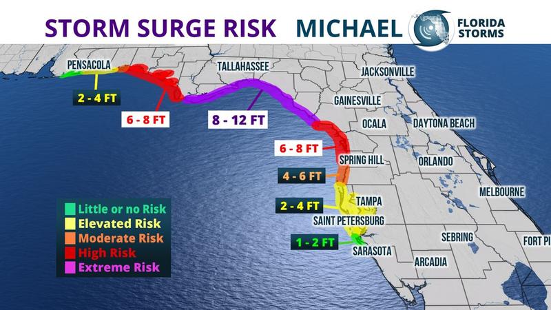
- Storm Surge Expected: 7-11 feet
Apalachicola
- TS-Force winds (40mph+): Already happening, lasting until nightfall (already had gusts over 50mph)
- Hurricane Force winds (75mph+): Just before Noon
- Worst conditions: 11a-6p
- Rainfall Expected: 6-10”
- Storm Surge Expected: 9-14 feet
Destin
- TS-Force winds (40mph+): Beginning now, lasting until 8p
- Hurricane Force winds (75mph+) begin: Around Noon
- Worst conditions: 12p-6p
- Rainfall Expected: 3-6”
- Storm Surge Expected: 5-8 feet
Pensacola
- TS-Force winds (40mph+) begin: In the next few hours, lasting until around 6pm
- Hurricane Force winds (75mph+) begin: Not expected to reach hurricane force
- Worst conditions: 12p-5p
- Rainfall Expected: 1-2”
- Storm Surge Expected: 2-4 feet
Tallahassee
- TS-Force winds (40mph+) begin: Wednesday afternoon, 2-3pm
- Hurricane Force winds (75mph+) begin: Only when the center is passing around 6-8p
- Worst conditions: 5p-10p
- Rainfall Expected: 6-10”
- Storm Surge Expected: N/A
As Green continues to monitor the storm, stay up-to-date on freight news by following us on Facebook, Twitter, and LinkedIn or, subscribe to Green’s Freight Talk blog to received updates directly to your email.